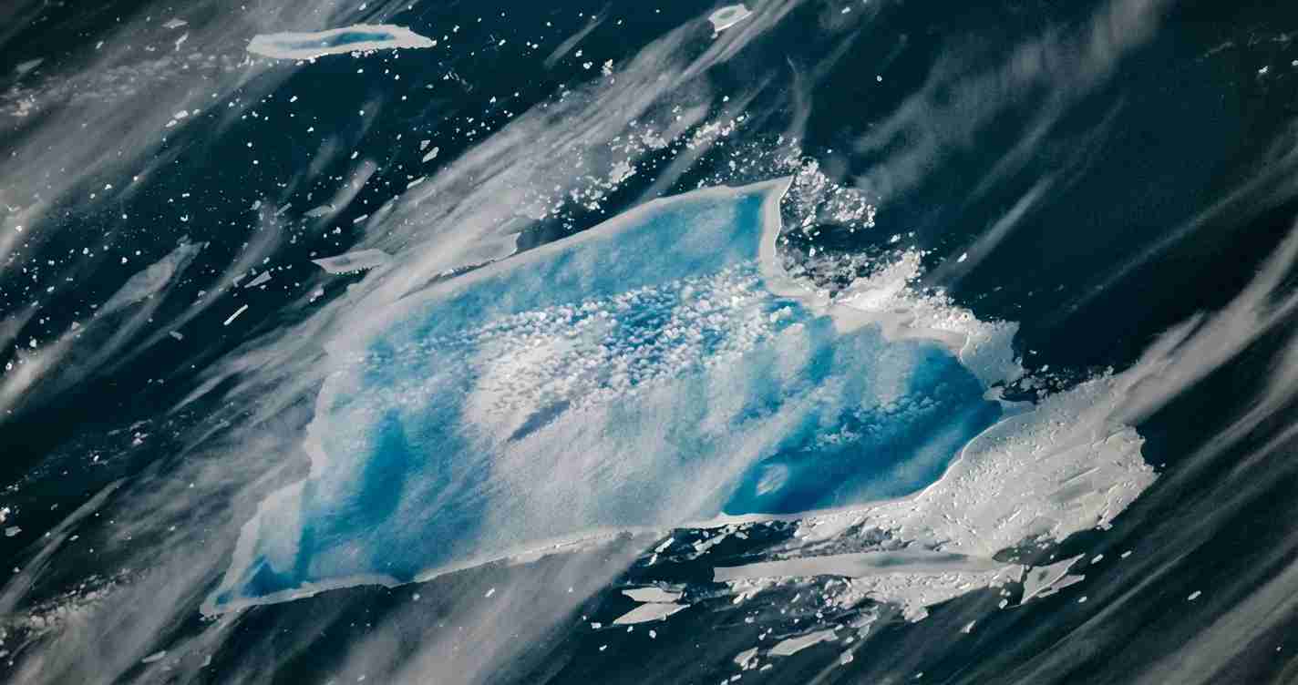
Reagan‑era megaberg A‑23A is now rapidly disintegrating — a blue Antarctic iceberg shrinking in the South Atlantic
Iceberg A‑23A, the long-lived Antarctic megaberg, is undergoing a dramatic disintegration in the South Atlantic, astonishing scientists with vibrant blue meltwater; after 30+ years grounded, the colossal iceberg—still larger than New York City—is rapidly fracturing and shrinking.
- Rare megaberg collapse: A‑23A has shifted from a decades-long grounding to rapid breakup and shrinkage, offering a rare view of megaberg disintegration.
- Blue meltwater visible from space: Surface ponds and channels absorb red wavelengths and reflect blue — a process detailed by NASA.
- Size and tracking: From ~4,000 km² in 1986 to an estimated 1,182 km² in early 2026 per the U.S. monitoring agencies.
- Local lessons: Though far from Nevada, the event feeds climate and policy conversations in places like Las Vegas, affecting planning, investment and public engagement.
Key information
Name: Iceberg A‑23A, a tabular iceberg that calved from the Filchner–Ronne Ice Shelf in 1986 (NASA; Wikipedia).
Original area (1986): about 4,000 km² (≈1,544 mi²), nearly twice the size of Rhode Island (NASA).
Current area (early 2026): estimated about 1,182 km² (456 mi²) after several large pieces broke off in mid‑2025; still larger than New York City but nearing complete disintegration (U.S. National Ice Center; NASA).
Location: drifting in the South Atlantic between the tip of South America and South Georgia Island, after years grounded in the Weddell Sea (NASA; British Antarctic Survey).
A long life and a slow start to movement
Grounding and longevity: A‑23A is unusual because it spent more than three decades grounded on the shallow seabed of the Weddell Sea. That grounding preserved the berg far longer than typical icebergs, which usually melt within a few years once they enter warmer waters (NASA; EUMETSAT).
Break free and transit: The berg finally broke free around 2020 and began a complex journey. Satellite sensors tracked it past the northern tip of the Antarctic Peninsula by late 2023. In December 2023, the research vessel RRS Sir David Attenborough sampled waters near the berg to study particles and nutrients released by melting ice (BAS; EUMETSAT).
The breakup in 2025 and the rapid shrinkage
Early 2025 status: Through early 2025 A‑23A remained among the world’s largest icebergs, measuring roughly 3,500 km² by January 2025 and tracked as the largest by some monitoring groups (NOAA/NESDIS).
Mid‑2025 breakup: As it drifted north into warmer summer waters in mid‑2025, large chunks calved off in July, August and September. By September the berg had shrunk to about 1,770 km², with individual pieces as large as 400 km² seen breaking away (Wikipedia; NASA).
NASA described the iceberg as “sopping with blue meltwater and on the verge of complete disintegration” in the South Atlantic between South America and South Georgia.
By late December 2025 and into early 2026, satellite imagery showed the berg saturated with meltwater, streaked with vivid blue pools and channels, and displaying rampart‑and‑moat patterns and freshwater plume blowouts (NASA).
Why the iceberg looks deep blue
Optics of melt ponds: Surface meltwater collects in depressions and cracks; when ponds fill channels the water absorbs longer red wavelengths and reflects blue light. Strong summer sunlight and the berg’s old, dense ice intensify the blue appearance (NASA).
Satellite imagery details: Photos taken in late December 2025 (including December 27, 2025) show raised white rims where edges melt at the waterline and lower interior areas where water ponds collect; some images show blowouts where ponded water punched through and created freshwater plumes (NASA).
How large icebergs break apart: the mechanics behind the scenes
Researchers point to several physical processes responsible for A‑23A’s rapid decline:
- Hydrofracturing: Heavy meltwater in surface cracks forces the ice apart from within (NASA).
- Edge melting: Warmer ocean water thins and undercuts the berg, weakening its edges (BAS; NASA).
- Wave and current stress: Waves carved archways and weakened structures in 2024; interactions with seafloor features like Pirie Bank and rotating ocean structures called Taylor columns altered drift and stress patterns (BAS; EUMETSAT).
Why scientists are watching A‑23A closely
A‑23A is a rare natural experiment: exceptional age (≈40 years since calving), megaberg scale, a long grounding phase, and a dramatic breakup as it entered warmer seas. That combination gives researchers an opportunity to study:
- Iceberg evolution: How very large icebergs evolve and disintegrate (NASA; BAS).
- Ocean nutrient dynamics: How massive freshwater inputs and mineral dust from icebergs influence nutrients, plankton blooms and local carbon cycles — field samples were taken by the RRS Sir David Attenborough (BAS).
- Hazard tracking: How satellite systems and ship observations track hazards to shipping as large chunks break away; agencies involved include NOAA/NESDIS, the U.S. National Ice Center and EUMETSAT.
Tracking and numbers
Size timeline: At calving in 1986 the berg was about 4,000 km² (≈1,544 mi²); by January 2025 it measured roughly 3,500 km²; by September 2025 it was about 1,770 km²; and the U.S. National Ice Center put the January 2026 area at about 1,182 km² (456 mi²) (NASA; NOAA/NESDIS; Wikipedia).
Public comparisons help convey scale: A‑23A began nearly twice the size of Rhode Island and now remains larger than New York City, helping non‑specialists grasp the berg’s magnitude (NASA; BAS).
Implications for Las Vegas, Nevada
Economic impact: Direct economic effects on Las Vegas are limited because A‑23A is far from Nevada and poses no immediate shipping or coastal hazard to the region. Still, high‑profile climate events can influence markets, insurance rates and municipal planning as national agencies such as NASA and NOAA/NESDIS inform policy and investors.
Political and social consequences: The dramatic imagery of a blue Antarctic iceberg breaking apart can shape local debates in Las Vegas about practical climate policy, water management, infrastructure spending and emergency planning — potentially increasing civic support for resilience and science‑based decision making.
Practical applications: City planners, tourism officials and utilities can use A‑23A as a case to justify investments in climate data, monitoring and resilience, informed by international cooperation among agencies like NASA, NOAA/NESDIS, EUMETSAT and BAS.
Reporting and sources
This story draws on satellite imagery and analysis from NASA’s Earth Observatory, tracking and updates from NOAA/NESDIS and the U.S. National Ice Center, field work and sampling by the British Antarctic Survey and the RRS Sir David Attenborough, and compiled monitoring by EUMETSAT. Additional references include Wikipedia (A23a) and public summaries archived online (TechEBlog).
Key URLs (preserved):