
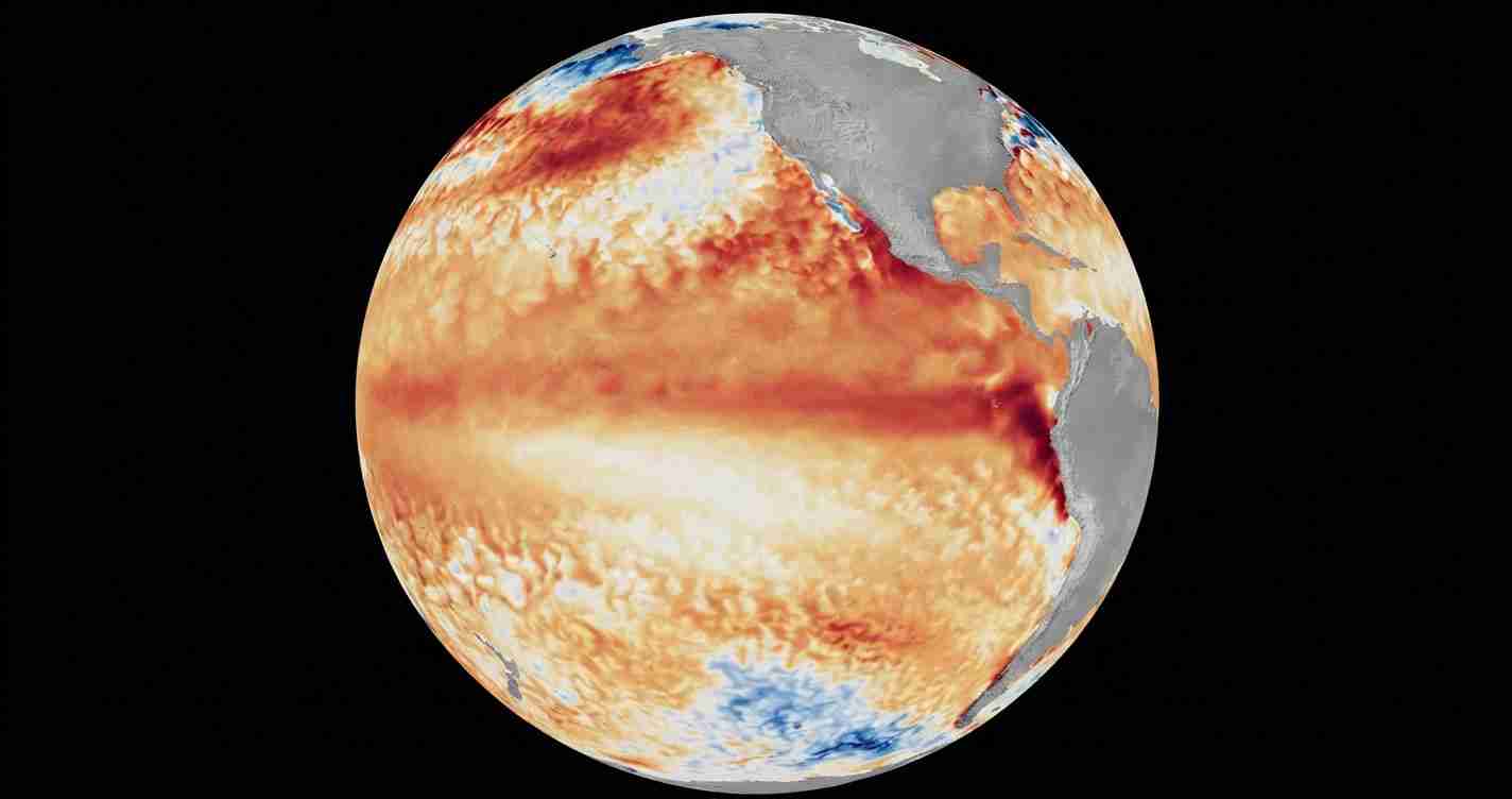
WASHINGTON, July 7 (San Diego News Online) — NOAA forecasters say El Niño is now underway in the equatorial Pacific and is expected to strengthen through the Northern Hemisphere winter of 2026-27.
The agency’s Climate Prediction Center issued an El Niño Advisory on June 11, saying El Niño conditions are present and that there is a 63% chance of a very strong event during November through January. For most readers, the practical takeaway is simple: follow NOAA’s seasonal outlooks and your local National Weather Service forecasts, especially if you live in a flood-prone coastal area or are planning for winter weather.
What is El Niño?
El Niño is the warm phase of ENSO, short for El Niño-Southern Oscillation. NOAA’s Climate.gov explains ENSO as a natural cycle in the tropical Pacific that can change weather patterns far beyond the ocean itself.
During El Niño, sea-surface temperatures in the central and eastern equatorial Pacific run warmer than average. That shift can affect storm tracks, rainfall, and winter temperatures in parts of the United States, but the effects are not the same everywhere.
What NOAA is seeing now
The Climate Prediction Center says El Niño conditions developed over the past month, with above-average sea-surface temperatures spreading across the central to eastern equatorial Pacific. In its latest advisory, the center reported weekly temperature indexes of +0.7 degrees Celsius for the Niño-3.4 region, +0.7 degrees Celsius for Niño-4, and +2.1 degrees Celsius for Niño-1+2.
Those regional indexes are ways forecasters track where the Pacific is warming. The center says its model blend, including the North American Multi-Model Ensemble and the NCEP CFSv2 model, points to El Niño strengthening into winter.
The International Research Institute for Climate and Society at Columbia also says El Niño conditions are strengthening across the tropical Pacific and that the event is likely to keep intensifying.
Why the timing matters
The most important part of NOAA’s forecast is the timing window. The Climate Prediction Center says the strengthening phase is expected during the Northern Hemisphere winter of 2026-27, with the highest chance of a very strong event during November through January.
That does not mean a single storm is on the way. It means the large-scale ocean-atmosphere pattern is in place, and forecasters expect it to remain strong enough to influence seasonal weather patterns.
What El Niño can change
NOAA says El Niño can tilt weather patterns across the United States. In general, it can change where wet and dry weather set up and can shift winter temperature patterns.
NOAA’s Ocean Service also says El Niño can raise the chance of high-tide flooding in some U.S. coastal locations. That does not apply everywhere, but it is one of the reasons coastal residents are often told to watch seasonal outlooks closely.
For people trying to plan ahead, the most useful step is to check local forecasts rather than assume one national pattern will fit every region. El Niño is a climate pattern, not a storm forecast.
What to watch next
NOAA forecasters will keep updating the outlook as ocean temperatures and atmospheric conditions change. The key question is whether the current warming continues to build toward the stronger category NOAA is now flagging for late fall and winter.
For now, NOAA’s message is clear: El Niño is already present, it is expected to strengthen, and the period from November through January is the window with the highest chance of a very strong event.
