
El Niño Poised to Ignite Eastern Pacific Hurricane Season — What That Means for 2026 Storms and Las Vegas
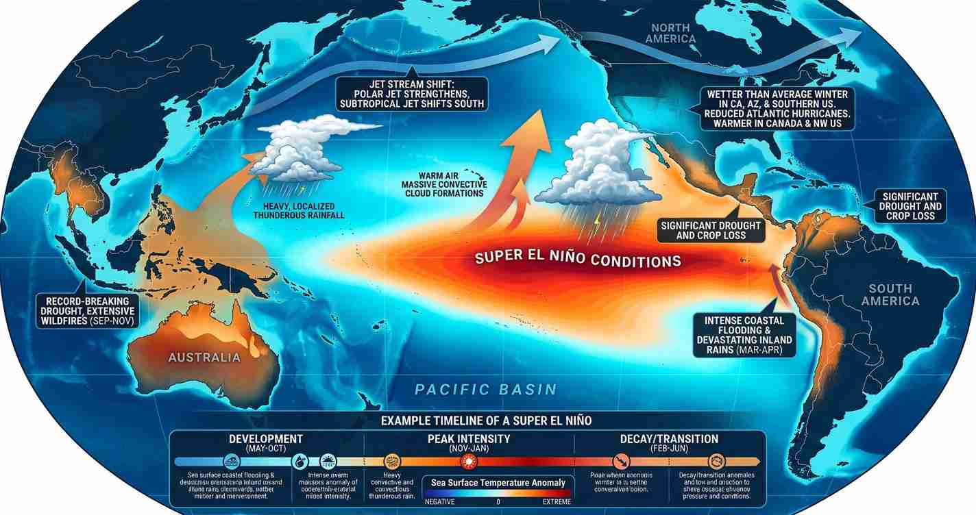
Climate models and historical data indicate El Niño will likely develop in mid‑2026, increasing Eastern Pacific hurricane activity with warmer sea surface temperatures and favorable atmospheric patterns that favor storm formation and rapid intensification — unlike typical Atlantic seasons.
- Higher odds of an active Eastern Pacific season: models and NOAA-linked guidance point to a greater-than-normal number of named storms in 2026.
- Rapid intensification risk: elevated sea surface temperatures and deep warm layers boost the chance storms strengthen quickly.
- Regional impacts beyond the coast: travel disruptions and shifted moisture patterns could affect Las Vegas tourism, events, and transportation.
How El Niño affects the East Pacific: the mechanism
El Niño — a periodic warming of the central and eastern equatorial Pacific — changes tropical atmospheric circulation in two key ways that favor Eastern Pacific hurricane activity.
1. Increased shear in the Atlantic, reduced competition for the Pacific
When El Niño strengthens, it often imposes stronger upper-level winds over the tropical Atlantic and Gulf, raising vertical wind shear that inhibits storm organization in the Atlantic basin. This is a primary reason Atlantic seasons often weaken during El Niño years. Sources: Fox Weather, YouTube explainer.
2. Enhanced Pacific convection and lower local shear
Warmer surface waters in the central and eastern Pacific increase convection (rising warm, moist air), which — combined with locally reduced shear and deep warm ocean layers — creates a more favorable environment for storm formation, organization, and rapid intensification. Sources: YouTube explainer, Fox Weather.
Why this could “ignite” the 2026 season
Several measurable oceanic and atmospheric signals point toward a notably active Eastern Pacific season in 2026:
- Warm ocean heat content: parts of the Eastern Pacific show SST anomalies up to 1–3°C above 1991–2020 norms, providing abundant fuel beneath storms. Sources: YouTube explainer, Fox Weather.
- Lower local shear: El Niño often reduces shear near the equator and off Mexico’s coast, allowing structures to remain intact and intensify.
- Deep subsurface warmth: deeper warm layers raise the probability of sudden intensification similar to past events such as Hurricane Otis (2023). Source: Fox Weather.
Forecast outlook and model signals
NOAA and several climate models — summarized in public reporting — give roughly a 61% chance of El Niño by May–July 2026 and about a 25% chance it could become a “super El Niño” by fall, which would amplify Eastern Pacific impacts. (Summarized in Time.)
Seasonal forecasts and official outlooks
Public seasonal outlooks, including commentary tied to national services, anticipate an above-average season. Some forecasts cited in public reports suggest:
- ~18–21 named storms
- ~9–11 hurricanes
- ~4–5 major hurricanes
Those ranges would exceed long-term averages and are reflected in season summaries such as the 2026 Pacific hurricane season page and reporting like Fox Weather.
Historical context and statistics
Since 1990, moderate-or-strong El Niño years have tended to produce above-average Eastern Pacific seasons. One public summary notes about 85% of those El Niño years were more active, averaging roughly 17 named storms, 9 hurricanes, and 5 major hurricanes versus long-term averages near 15, 8, and 4. Sources: YouTube explainer, Fox Weather.
Season details to watch
- Official season dates: Eastern Pacific runs May 15–Nov. 30, 2026 (Central Pacific June 1–Nov. 30). Sources: Fox Weather, Wikipedia.
- Early-season cues: June development, SSTs, subsurface heat, wind shear, and intraseasonal pulses like the Madden‑Julian Oscillation (MJO) will be monitored. Source: YouTube explainer.
Implications for Las Vegas, Nevada
While direct hurricane strikes on Las Vegas are unlikely due to geography, an active Eastern Pacific season can have meaningful secondary effects on the city’s economy, services, and events.
Economic impact
Travel and tourism are particularly vulnerable: storms hitting Mexico and Baja can disrupt flights through hubs such as Los Angeles, Phoenix, and San Diego, creating ripple effects at Harry Reid International Airport and affecting conventions, shows, and hotel bookings. Source: Fox Weather.
Political consequences
State and local officials may need to reassess emergency plans, transportation resilience, and disaster-preparedness funding if widespread disruptions occur. Coordination with federal agencies and airlines may increase during peak threats. Sources: Time, public season outlooks.
Social effects
Travel disruptions can displace tourists and create short-term shelter or service demands. Local nonprofits and city services could see increased needs if events are canceled or visitors are stranded. Residents are advised to consider flexible bookings and travel insurance. Sources: Time, Fox Weather.
Cultural relevance and weather links to the Southwest
Tropical moisture from Eastern Pacific storms can ride northward, sometimes modifying the North American monsoon or producing heavy rain and flash flooding in the Southwest — effects that can disrupt outdoor pools, concerts, festivals, and regional road safety. Source: ENSO reporting and briefings such as YouTube explainer.
Practical applications for residents and visitors
- Track official forecasts: follow NOAA and local NWS offices and trusted media for updates (coverage summarized in Time).
- Prepare flexible travel plans: consider refundable tickets and travel insurance during peak months.
- Event and business planning: review contingency plans for transportation disruption and supply-chain risks tied to Pacific port impacts. Sources: Fox Weather, SMN/season briefs summarized publicly (Wikipedia).
“NOAA and model guidance put roughly a 61% chance of El Niño by May–July 2026, with about a 25% chance of a super El Niño by fall,”— public summaries cited in Time.
Sources and further reading
- Fox Weather: “El Niño could boost hurricane activity in the Eastern Pacific in 2026”
- Time: “What to know about a possible super El Niño in 2026”
- Wikipedia: 2026 Pacific hurricane season (season summary and national forecasts)
- ENSO explainer video (YouTube: osW5wCPwSJM)
- ENSO explainer video (YouTube: JlHLQ_4U3t8)
Reporting drew on public forecasts, climate model briefings and season outlooks cited above. Residents and planners should rely on NOAA and local National Weather Service advisories for official warnings.
